
hook-365/adsb-3d
hook-365/adsb-3d has 58 GitHub stars and 7 forks. GitHot measured +2 in 7 days. Last checked 2026-11-15 15:37 UTC. Last push 2026-11-05.
Measured star growth
- in 24h
- Update delayed
- in 7 days
- +2
- in 15 days
- Update delayed
- in 1 month
- Update delayed
Net star changes over overlapping periods, not daily totals. Missing measurements are left blank. Stars measure attention, not software quality.
About
Real-time and historical 3D visualization of ADS-B aircraft data with 7 visual themes, mini radar, and interactive controls
Self-hostedREADME.md
OriginalADS-B 3D



Real-time 3D visualization of ADS-B aircraft, with historical playback, 3D airway-density heatmaps, and optional ACARS message decoding. One Docker image: it serves the viewer and reverse-proxies your existing ADS-B feeder. Runs on your desktop, your phone, and, with a headset, your coffee table.
Works with anything that publishes readsb's aircraft.json — tar1090,
ultrafeeder, dump1090-fa, readsb-protobuf, and so on.
Live demo → — explore a running instance in your browser.
Built with the community
- @tyzbit: asked for VR (#6) and then Quest-3-tested every VR/AR release with annotated videos; the altitude-scale idea (#8).
- @ValkyrieUK: the full-stack Docker integration tests and CI (#9), plus a retention bug every fresh install had.
- @unLieb: scoped the localization architecture (#10); German native review.
- @rknobbe: 3D terrain (#7), tab-scoped settings (#12), real balloons and airships (#13), routes on live-only installs (#15).
- @auggiesoft: contributed smooth motion (#14).
- @dirkhh: runs adsb.im, the source of every route here, and asked for the batching that became the shared route cache (#16). If routes are useful to you, support adsb.im.
Want your name here? Issues with reproduction steps, hardware testing, and translations count just as much as code.
What's new
- v0.13 (unreleased, on
master): Glass or Docked panel style; RainViewer weather radar; emergency toasts with the squawk on the label; a what's-new note once per version; reduced-motion defaults; 24 h shared route cache. - v0.12: shared route cache and batched, identified requests to adsb.im (#16); one
VERSIONeverywhere; daily update check with an in-app badge. - v0.11: smooth motion between position updates (by @auggiesoft); routes on live-only installs with an "Unverified" mark when they do not fit the aircraft's position; per-tab settings; upright balloons and airships.
- v0.10: AR diorama matured: placeable, resizable clip box, auto-orbit, follow-random-aircraft, high-res basemap option.
- v0.9: ACARS panel on the map with decoded messages and position pings; CARTO basemaps browser-direct under your own key; the hardening release (security headers, rate limiting, 750+ tests in CI).
- v0.7: real 3D aircraft bodies built from each tar1090 silhouette.
Full history in CHANGELOG.md and on the releases page.
What you get
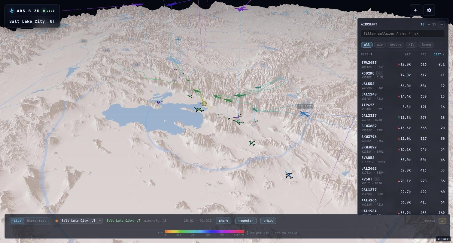
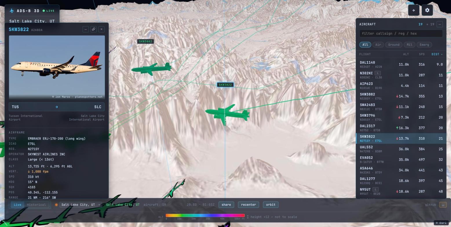
- Live mode: per-second updates, tar1090 altitude colours on cones, trails, ground icons and labels. Click an aircraft for photo, route, airframe and autopilot data. Filter pills (
All / Air / Ground / Mil / Emerg) drive the list and the scene. Mobile-friendly.
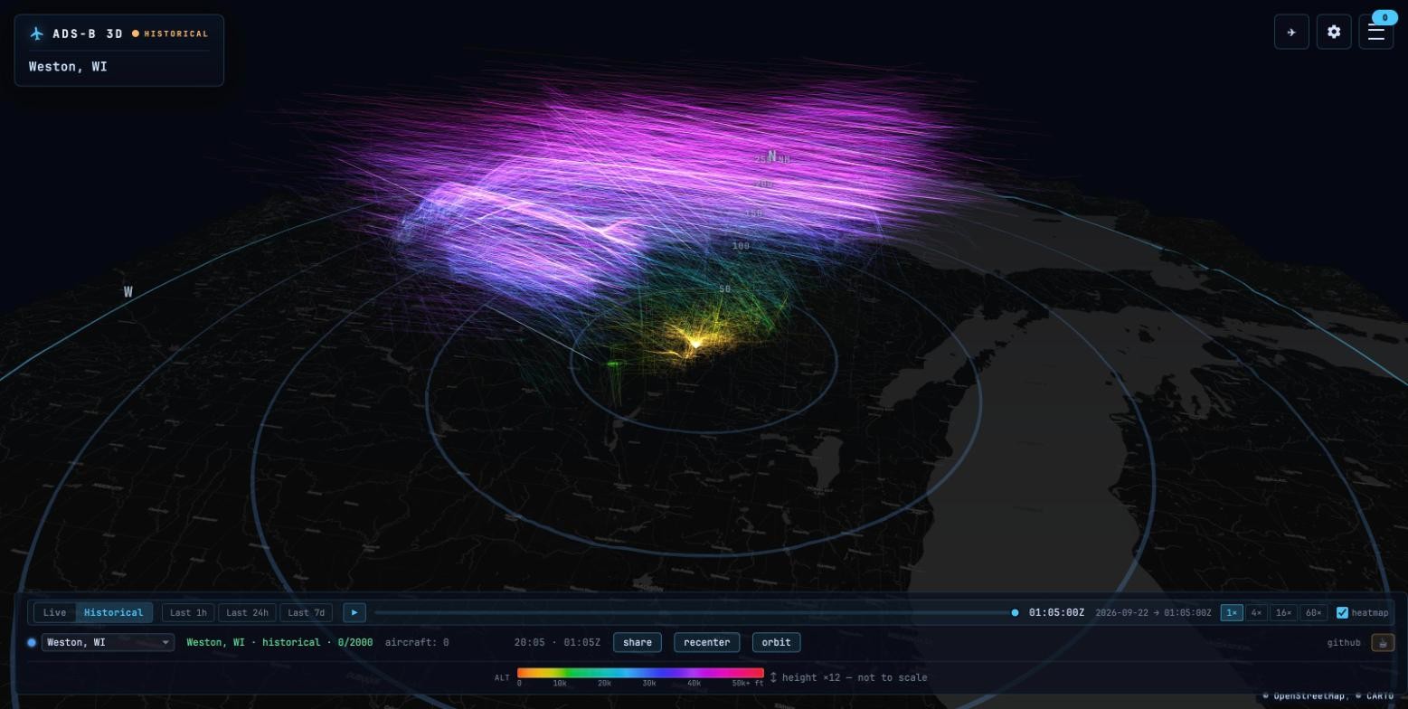
- Historical mode (track-service + TimescaleDB): scrub the last 1h / 24h / 7d at 1x to 60x, with a 3D airway-density overlay that draws every flight path at its real altitude.
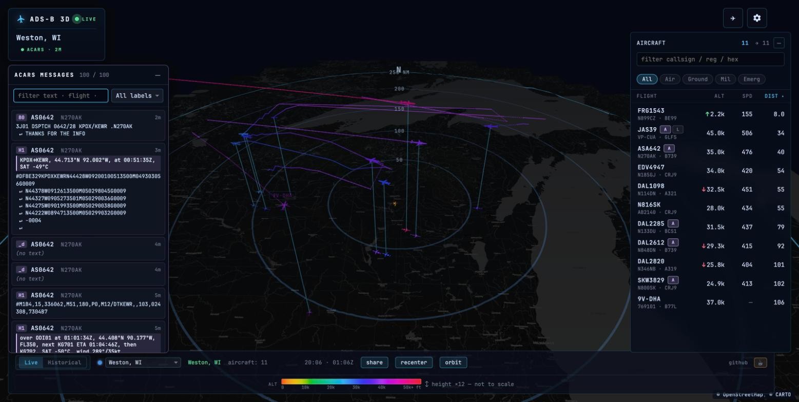
- ACARS (acars-service): a searchable message panel, per-aircraft messages in the detail card with an OOOI phase chip, an
Abadge on label and list row, and decoded summaries for position reports, arrivals, weather and CPDLC/ADS-C/AFN (details in acars-service/README.md). Messages with coordinates drop a position ping on the map, even beyond ADS-B range.
- Weather radar: RainViewer precipitation over any basemap, refreshed every few minutes, proxied and cached by nginx, credited on screen while on.
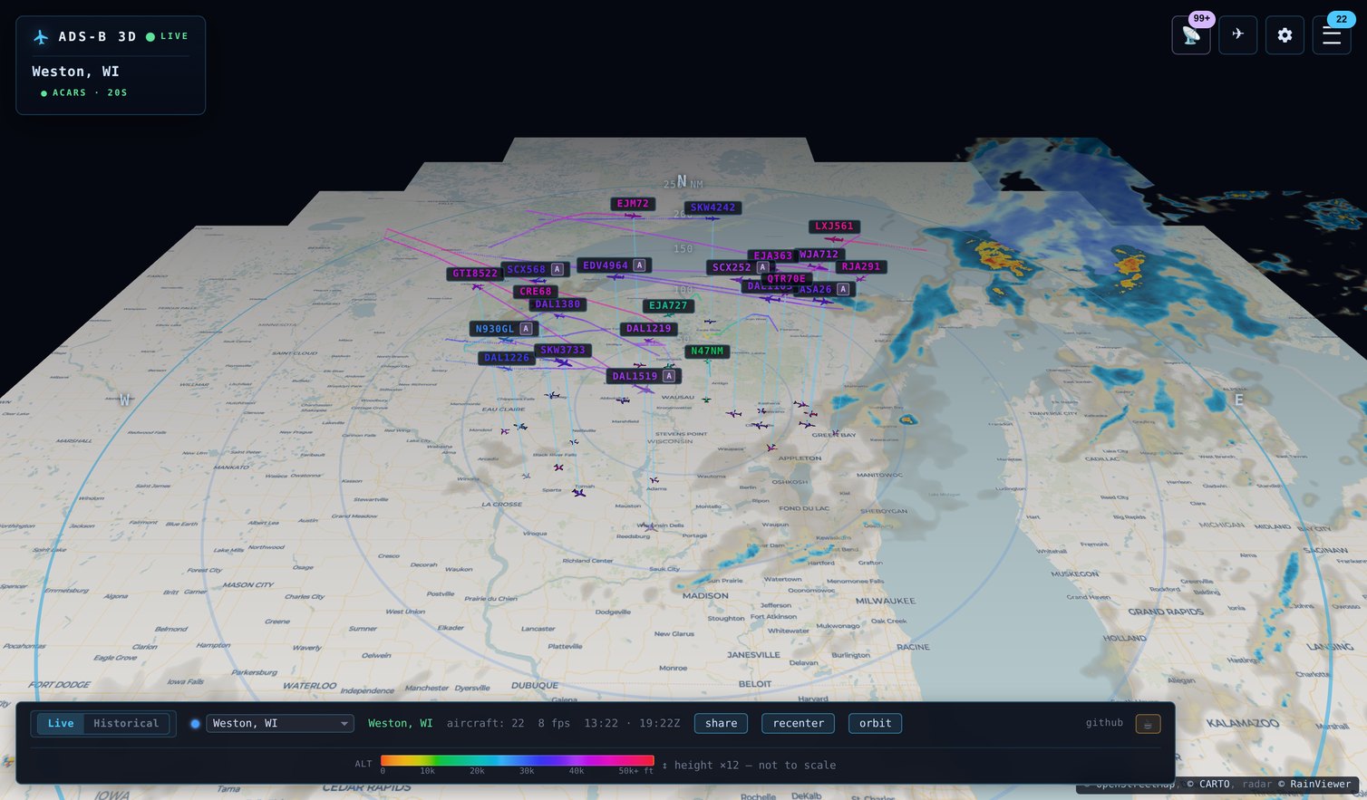
- Emergency alerts: squawk 7500 / 7600 / 7700 raises a toast (click to select), a red label with the squawk beside the flight name, and a pulsing ground ring. Live only, no sound.
- Panel style: Glass floats cards over the map; Docked attaches solid panels to the edges with the map credit inside the footer.
- Multi-feed: several receivers, a feed picker in the status bar, in-place switching.
- Themes: Midnight Glass, Daylight, Sectional Chart, Phosphor CRT, High Contrast, or
Autofrom your system preference. The 3D scene re-tints live. - Languages: English, German, Spanish (machine-drafted pending native review; corrections welcome).
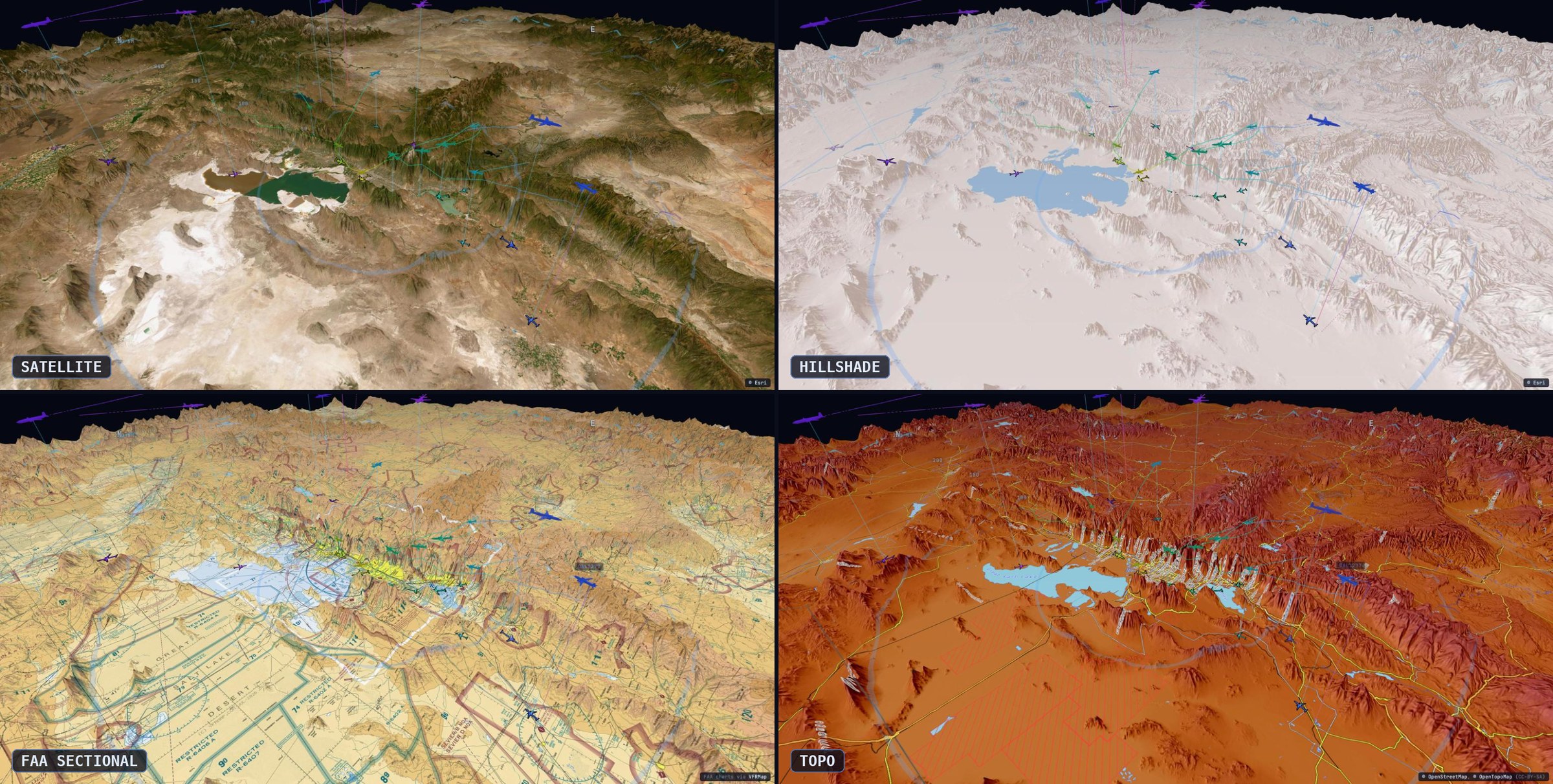
- 3D terrain (opt-in): the basemap rises to real elevation with rings, markers and ground icons draped over it; free data, no key. An altitude scale slider warps the vertical axis toward pattern or flight-level detail.
- VR / AR: WebXR with laser-pointer controllers, a wrist menu with full settings parity, comfort locomotion, AR scope placement and the diorama clip box. Quest 3 tested; demo in VR & AR. Side-by-side stereo for anything without WebXR.
- Basemaps: OpenStreetMap, OpenTopoMap, ESRI relief and satellite, FAA charts, and CARTO Dark / Voyager with your own free
CARTO_API_KEY(browser-direct, as their terms require). Attribution always on screen. Optional high-res mode fetches one zoom level deeper.
- Keyboard and screen readers: the aircraft list is a real listbox with arrow-key navigation, proper roles, a keyboard-operable ACARS panel, and a throttled live count.
Prerequisites
- Docker Engine 20+ and Docker Compose v2
- An ADS-B feeder already publishing
aircraft.json(tar1090, ultrafeeder, dump1090-fa, readsb-protobuf, …)
Quick start
services:
  adsb-3d:
    image: ghcr.io/hook-365/adsb-3d:latest
    ports: ["8086:80"]
    environment:
      - LATITUDE=45.0000
      - LONGITUDE=-90.0000
      - ALTITUDE=1000
      - LOCATION_NAME=My Station
      - FEEDER_URL=http://ultrafeeder
docker compose up -d, then open http://localhost:8086/ — your
aircraft should appear within a few seconds.
FEEDER_URL must be reachable from inside the container. A bare
service name like http://ultrafeeder only resolves if adsb-3d shares a
Docker network with your feeder. If it doesn't, use the feeder's host IP
and port — e.g. http://192.168.1.50:8080. If the page loads but stays
empty, this is almost always why: check docker logs adsb-3d (the
container reports unhealthy until it can reach the feeder).
For historical playback, ACARS, or the voice scanner, copy
.env.example to .env and start from docker-compose.example.yml
in the repo root. Both have track-service, ACARS, and TimescaleDB
ready to uncomment; the ENABLE_* flags below switch each on.
VR & AR
Put the airspace on your desk. With a WebXR headset the scope becomes a walkable diorama: orbit a selected aircraft, free-fly through the traffic, change settings from a wrist menu, or enter AR and drop the map onto real furniture with a glance and a trigger pull. Diorama clipping keeps it desk-sized — the map pans beneath a fixed, resizable open-top box — and auto-orbit slowly circles the scope (or your followed aircraft) like a live model.
https://github.com/user-attachments/assets/a8a1f6ba-8fe8-4c3b-ad88-d2dae76e2281
Demo recorded on a Quest 3 by @tyzbit, who hardware-tested every iteration of these features. The full-length demo is attached to the v0.6.0 release.
Reverse proxy
adsb-3d runs on a subdomain or a subpath (example.com/3d). The
entrypoint auto-detects the subpaths /3d, /adsb, and /adsb-3d when
your proxy passes the prefix through; set BASE_PATH if the proxy strips
the prefix or uses a different path. Worked configs for nginx, Traefik,
Caddy, Apache, and Nginx Proxy Manager are in
docs/REVERSE-PROXY.md.
Multi-feed
Define each feed with flat FEEDN_* env vars — the entrypoint
synthesises the rest:
FEED1_NAME=Home Station
FEED1_LAT=45.0000
FEED1_LON=-90.0000
FEED1_ALT=1000                # feet MSL, like all altitudes here
FEED1_ACARS=true              # optional

FEED2_NAME=Remote Site
FEED2_URL=192.0.2.10:8086     # host:port of another adsb-3d instance
FEED2_LAT=43.0000
FEED2_LON=-89.0000
FEED2_COLOR=#ff8c4c           # optional
Slot 1 is always local — FEED1_URL is ignored. Slots 2+ point at other
adsb-3d instances and the entrypoint wires up the nginx proxy blocks.
Parsing stops at the first missing FEEDN_NAME.
Environment variables
Core:
| Variable | Default | Purpose |
|---|---|---|
LATITUDE / LONGITUDE / ALTITUDE |
— | Receiver location; ALTITUDE in feet MSL (as are all FEEDN_ALT) |
LOCATION_NAME |
Home |
Display name |
FEEDER_URL |
http://ultrafeeder |
Anything publishing /data/aircraft.json — must be reachable from the container |
ENABLE_HISTORICAL |
false |
Historical playback UI (needs track-service) |
ENABLE_ACARS |
false |
ACARS panel (needs acars-service) |
ENABLE_VOICE |
false |
VHF voice scanner panel (see docs/VOICE.md) |
ENABLE_TERRAIN |
true |
Deploy-level 3D-terrain kill switch (users still opt in per-browser) |
ENABLE_UPDATE_CHECK |
true |
The container asks GitHub once a day for the latest release and the settings panel shows a badge when it is newer. Runs server-side only (one request per deployment per day, no viewer IPs); false disables it entirely |
HIDE_TOWER |
false |
Hide the home tower marker |
TRACK_API_HOST |
track-service:8000 |
nginx upstream |
ROUTE_CACHE_TTL_SECONDS (track-service) |
86400 |
How long the shared route cache keeps an answer before asking adsb.im again |
ROUTE_API_CONTACT (adsb-3d and track-service) |
— | Contact (email or site) sent to adsb.im and tile providers in the User-Agent (adsb-3d/<version> (+repo; contact)); they ask for one. Unset = no contact sent, warning at start |
ACARS_API_HOST |
acars-service:8000 |
nginx upstream |
VOICE_EVENTS_HOST |
— | nginx upstream for /voice/calls + /voice/ws — what the frontend uses |
VOICE_STREAM_HOST |
— | required when voice is on; point at any reachable host:port (legacy Icecast block, not played by the frontend) |
CARTO_API_KEY |
— | Free CARTO basemaps key that unlocks the Carto Dark and Carto Voyager basemaps. Fetched by the browser directly from CARTO (their terms forbid proxying), one key per deployment. Without it those two entries are hidden and the default basemap falls back to OpenStreetMap |
DNS_RESOLVER |
127.0.0.11 |
nginx resolver address(es) for upstream lookups; override on runtimes without Docker's embedded DNS (e.g. Kubernetes CoreDNS) |
MAP_ZOOM / MAP_GRID_SIZE |
8 / 21 |
boot-time tile pre-cache around the station (zoom level / grid width); only active with the /tiles volume mounted |
Multi-feed: FEEDN_NAME, FEEDN_LAT, FEEDN_LON, FEEDN_ALT,
FEEDN_URL, FEEDN_COLOR, FEEDN_ACARS — see Multi-feed.
(FEEDS_CONFIG accepts the raw JSON feed array directly and skips the
FEEDN_* synthesis — see .env.example for the shape.)
Backend services (track-service / acars-service containers, not
the main image — see the compose example):
| Variable | Default | Purpose |
|---|---|---|
FEEDER_URL |
http://ultrafeeder |
same feeder the frontend uses; both services poll it |
FEEDER_POLL_SECONDS |
heuristic | live-stream poll cadence override (defaults per feeder type) |
COLLECTION_INTERVAL |
5 |
seconds between DB track snapshots (track-service) |
RETENTION_DAYS |
90 |
TimescaleDB retention for tracks and ACARS messages |
DB_HOST / DB_PORT / DB_NAME / DB_USER / DB_PASSWORD |
timescaledb-adsb / 5432 / adsb_tracks / adsb / — |
TimescaleDB connection; password has no default on purpose |
ACARS_HOST / ACARS_PORT |
acarshub / 15550 |
acarshub / acars_router JSON-over-TCP feed (acars-service); 15550 is the ACARS lane, 15555 VDL Mode 2 |
ACARS messages are decoded into human-readable summaries (position reports, arrivals, weather requests, and CPDLC/ADS-C/AFN datalink) shown above the raw text; see acars-service/README.md.
| STATION_ID | adsb-3d | station identifier stamped on stored ACARS messages |
Reverse proxy: BASE_PATH overrides the auto-detected subpath
(see Reverse proxy). TRUSTED_PROXY_CIDR (comma-
separated CIDRs) makes rate limiting key on the real client IP behind
a fronting proxy instead of one shared bucket. CORS_ALLOW_ORIGIN
(default empty = no CORS headers) opts a specific origin — or * —
back in if another site consumes the API directly.
Controls
Mouse: left-drag orbits the camera, scroll zooms, right-drag pans the view (moves the center point).
| Key | Action |
|---|---|
| Arrow keys | Pan the view across the map |
R |
Recenter camera + clear selection |
/ |
Focus the list search box |
Esc |
Close settings panel or ACARS panel |
Upgrading
Pull the new image and restart; settings and data carry over. From 0.12.2 the settings panel shows an Update available badge when a newer release exists, and the first load after an upgrade shows what changed.
Routes (origin / destination) stopped showing? Releases before
0.12 sent route lookups to adsb.im one callsign at a
time and may be rate-limited or blocked there. Pull a current image
(:latest or 0.12.2+) and restart; routes come back, and from 0.12.2
the settings panel tells you when a newer release exists. See
#17.
Full detail in CHANGELOG.md.
Versioning
VERSION at the repository root is the single source of truth. Every image
copies it at build time and reports it everywhere a version appears: the
settings panel (v0.12.1), the /api and /acars-api root endpoints, the
nginx User-Agent sent to adsb.im and tile providers, and track-service's
adsb-3d/<version> track-service agent. Images built from a commit that is
not a release tag carry build metadata (0.12.1+a1b2c3d, or +local for a
local compose build), so a non-release build can never be mistaken for the
published one. Releases are cut with scripts/release.sh X.Y.Z; CI refuses
to publish if VERSION, frontend/package.json and the tag disagree.
Architecture
                ┌──────── browser ────────┐
                │  Vite/TS Three.js app   │
                └───────────┬─────────────┘
                            │
                       nginx (port 80)
                            │
      ┌──────────┬──────────┼──────────┬──────────────┐
      │          │          │          │              │
   /data/...  /api/...   /ws/...  /api/feeds/N/...  /acars-api/
      │          │          │          │              │
 ultrafeeder  track-service │   remote adsb-3d   acars-service
                  │             instance (slot N)
                  ▼
            TimescaleDB
       (aircraft_positions
        + aircraft_metadata
        + acars_messages)
frontend/— Vite + TypeScript + Three.js viewer, no framework.track-service/— FastAPI + asyncpg; a live WebSocket diff stream plus a TimescaleDB history collector.acars-service/— FastAPI bridge to an acarshub TCP feed.nginx/— reverse proxy + static host;entrypoint.shrenders the config (including per-feed proxy blocks) from env vars at start.
See CLAUDE.md for a deeper architecture orientation.
Development
cd frontend
npm install
npm run dev         # Vite dev server
npm run typecheck   # tsc, strict
npm run test        # Vitest
npm run build       # → dist/
npm run dev proxies backend routes to http://localhost:8080; override
with DEV_BACKEND. To run the full container against an existing backend:
docker compose -f docker-compose.dev.yml --project-directory . up --build -d
# → http://localhost:8186/
Credits
- tar1090 (wiedehopf/tar1090, GPL v2+) — SVG aircraft shape catalog and the altitude → color palette.
- readsb / dump1090-fa — upstream Mode S/ADS-B decoder.
- planespotters.net — aircraft photographs in the detail panel.
- adsb.im — callsign → route resolution, run by one person as a hobby service. Lookups are cached and batched to keep the load small; please keep it that way if you fork this.
- OpenStreetMap, ESRI, OpenTopoMap — basemap tile providers, proxied and cached by the container; credited on screen.
- CARTO — Dark / Voyager basemaps, fetched directly by the browser under your own free API key per CARTO's basemap terms (5M tiles/month fair-use, OpenStreetMap + CARTO attribution required, no server-side caching).
- VFRMap — hosting for FAA Sectional / Helicopter / IFR Low / IFR High chart tiles, kept in sync with the FAA 56-day cycle. Free non-commercial service; please don't abuse it.
License
Source code is MIT (see LICENSE). Vendored tar1090 data
(frontend/src/aircraft/shapes-data.json) is GPL v2+ per upstream — if
you redistribute the built app, GPL governs that component.