
Yarroudh/segment-lidar
Yarroudh/segment-lidar has 367 GitHub stars and 42 forks. GitHot measured 0 in 7 days. Last checked 2026-11-10 01:33 UTC. Last push 2026-10-24.
Python package for segmenting LiDAR data using Segment-Anything Model (SAM) from Meta AI.
Measured star growth
- in 24h
- Update delayed
- in 7 days
- 0
- in 15 days
- Update delayed
- in 1 month
- Update delayed
Net star changes over overlapping periods, not daily totals. Missing measurements are left blank. Stars measure attention, not software quality.
README.md
Original
segment-lidar



Python package for instance segmentation of aerial LiDAR data using the Segment Anything Model 3 from Meta AI.
segment-lidar projects a 3D point cloud into an image, uses SAM 3 to find
objects, and transfers the instance labels back to the original points. It
supports automatic mask generation, text prompts, box prompts, top views,
pinhole cameras, saved label rasters, ground filtering, and LAS or LAZ output.
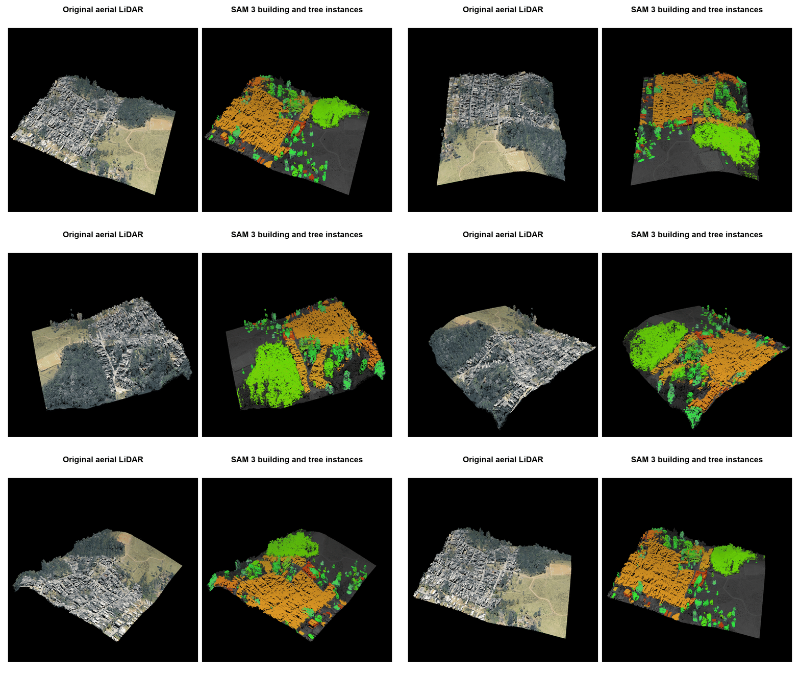
This animation shows a real SAM 3 result on a tile from the
Sao Paulo M3DC aerial LiDAR archive.
The source has 5,556,802 RGB points. The buildings prompt found 28 masks and
the tree prompt found 96 masks. After resolving overlap, the result contains
28 building instances, 87 visible tree instances, and 2,907,279 labeled source
points. Both views use the same rotating perspective camera so the 3D structure
remains visible.
The 0.3 series uses the gated facebook/sam3 model on Hugging Face. Inference runs locally after the model files are downloaded.
Installation
Use Python 3.10 or newer. A CUDA GPU is recommended for SAM 3 inference. Install the package and its SAM 3 dependencies from PyPI:
python -m pip install "segment-lidar[sam3]"
You can also install the current source version:
git clone https://github.com/Yarroudh/segment-lidar
cd segment-lidar
python -m pip install -e ".[sam3]"
Ground filtering is optional:
python -m pip install "segment-lidar[csf]"
Documentation
Read the complete documentation for detailed usage guidance. The basic tutorial and API reference describe the available parameters.
The migration guide explains changes from the earlier SAM 1 documentation.
Basic tutorial
Set HF_TOKEN before the first SAM 3 inference call. The
Model access section explains how to request access and create
a token.
Without ground filtering
With no prompt, segment uses automatic mask generation to find instances
across the projected image.
from segment_lidar import SamLidar, TopView

viewpoint = TopView()
model = SamLidar(resolution=0.25)
points = model.read("pointcloud.las")
segment_ids, labels, image = model.segment(
    points,
    view=viewpoint,
    image_path="raster.tif",
    labels_path="labels.tif",
)
model.write(points, segment_ids, save_path="segmented.las")
The label raster uses 0 for the background and positive integers for object
instances. Points on the background or outside the image receive -1.
With ground filtering
from segment_lidar import SamLidar, TopView

viewpoint = TopView()
model = SamLidar(resolution=0.25)
points = model.read("pointcloud.las")
cloud, non_ground, ground = model.csf(points)
segment_ids, labels, image = model.segment(
    cloud,
    view=viewpoint,
    image_path="raster.tif",
    labels_path="labels.tif",
)
model.write(
    points,
    segment_ids,
    non_ground=non_ground,
    ground=ground,
    save_path="segmented.las",
)
The indices returned by csf refer to the original cloud. The writer preserves
the point order and adds a signed 32 bit segment_id dimension.
Text prompts
Use a text prompt to find every visible instance of a concept:
segment_ids, labels, image = model.segment(points, prompt="building")
model.text_prompt.score_threshold and
model.text_prompt.mask_threshold control the result. Both accept values from
0 to 1 and default to 0.5.
Box prompts
Boxes use image pixel coordinates in the order
[left, top, right, bottom]. A label of 1 marks a positive box and 0 marks a
negative box. Text and boxes can be combined.
import numpy as np

segment_ids, labels, image = model.segment(
    points,
    prompt="tree",
    boxes=np.array([[80, 40, 180, 220], [210, 30, 300, 160]]),
    box_labels=np.array([1, 0]),
)
A positive box also works without text. With no text or boxes, the library uses automatic mask generation.
Saved label rasters
Saved labels can be transferred to a point cloud without loading SAM 3 or providing a Hugging Face token. Provide a three band RGB raster and a single band integer label raster with matching dimensions.
model = SamLidar(resolution=0.25)
segment_ids, labels, image = model.segment(
    points,
    image_path="raster.tif",
    labels_path="labels.tif",
    image_exists=True,
    label_exists=True,
)
New top view GeoTIFF files include a spatial transform. This allows a subset of the original cloud to use a saved image and label raster.
Pinhole camera
For camera geometry, numeric projection examples, and a complete saved-raster workflow, see the pinhole camera guide.
The package supports a custom pinhole camera. rotation and translation
transform world points into camera coordinates. intrinsics is a 3 by 3
camera matrix.
import numpy as np

from segment_lidar import PinholeView, SamLidar

intrinsics = np.array([[500, 0, 256], [0, 500, 256], [0, 0, 1]])
model = SamLidar(
    intrinsics=intrinsics,
    rotation=np.eye(3),
    translation=np.zeros(3),
    width=512,
    height=512,
)
segment_ids, labels, image, intrinsics, pose = model.segment(
    points,
    view=PinholeView(),
    prompt="tree",
)
The nearest point appears at each pixel. The optional distance_threshold
measures positive camera depth.
Sample data
The release animation uses the RGB aerial LiDAR tile MDS_color_2222-212.laz from the Sao Paulo M3DC archive. The archive provides many urban tiles with buildings, trees, roads, and other objects. Review the dataset page for its license and attribution requirements.
The animation source, parameters, and attribution are recorded in assets/README.md.
Model access
SAM 3 is gated on Hugging Face. A token does not grant access by itself. Use the same Hugging Face account for the access request and the token:
- Sign in to Hugging Face and open the facebook/sam3 model page.
- Read the conditions, submit the access request, and agree to share the requested account information with Meta.
- Wait until access is approved. Approval may be immediate or may require a review by the model owner.
- Create a Hugging Face token with read access to the model. A token limited to this model is preferable.
- Provide the token through
HF_TOKENor thehf_tokenargument ofSamLidar.
For a shell session, enter the token without displaying it:
read -rs HF_TOKEN
export HF_TOKEN
Do not put a real token in a script, notebook, Docker image, or commit. If access is pending, the library reports a permission error with a link to the model page. Access requests must be completed on Hugging Face.
Manual SAM 1 checkpoint downloads are no longer used. The Hugging Face client downloads the SAM 3 files into its local cache when inference starts.
Docker Image
The repository includes a Docker image for the SAM 3 runtime. The model files are downloaded when inference starts, so the token is supplied when the container runs rather than when the image is built.
These are the steps to run segment-lidar in a Docker container:
- Build the current image from the repository:
docker build -t segment-lidar:local .
- Create a local
.envfile containing your approved Hugging Face token:
HF_TOKEN=your_token_here
- Put your data and processing script in a local
datadirectory. Run the script with a GPU and mount that directory at/data:
docker run --rm --gpus all --env-file .env \
  -v "$PWD/data:/data" segment-lidar:local python /data/process.py
Output written to /data is immediately available in the local data
directory. Docker needs the NVIDIA container runtime for --gpus all.
- For CPU inference, omit
--gpus all. SAM 3 can be slow on a CPU:
docker run --rm --env-file .env \
  -v "$PWD/data:/data" segment-lidar:local python /data/process.py
Use --build-arg INSTALL_EXTRAS= during the build to create a smaller image
for projection and saved label workflows that do not load SAM 3.
Development
Install the development dependencies and run the project checks:
python -m pip install -e ".[test]"
ruff check segment_lidar tests scripts
ruff format --check segment_lidar tests scripts
pytest -q
python -m build
To reproduce the animation, download the sample tile and run:
python scripts/make_animation.py --sample /path/to/MDS_color_2222-212.laz
The generator reads HF_TOKEN from the environment or a local .env file.
It runs separate buildings and tree prompts, preserves their instance
labels, and renders the synchronized rotating views. Repeat --prompt to use
other concepts. Use --labels with a saved combined label raster to render
the animation without repeating inference.
Related repositories
We acknowledge the creators and maintainers of:
These projects provide the segmentation model and geospatial work that informed the development of this package.
License
This software uses the BSD 3 Clause New or Revised license. This permissive license allows broad use of the software as long as the copyright and license notice are included. Refer to the LICENSE file for the complete terms.
Citation
If you use this repository in research, cite it with the accompanying BibTeX citation:
@misc{yarroudh:2023:samlidar,
  author = {Yarroudh, Anass},
  title = {LiDAR Automatic Unsupervised Segmentation using Segment-Anything Model (SAM)},
  year = {2023},
  howpublished = {GitHub Repository},
  url = {https://github.com/Yarroudh/segment-lidar}
}
Yarroudh, A. (2023). LiDAR Automatic Unsupervised Segmentation using Segment Anything Model (SAM). GitHub repository.
Author
This software was developed by Anass Yarroudh, a Research Engineer in the Geomatics Unit of the University of Liege. For more information, contact [email protected].
Copyright 2023, Geomatics Unit of ULiège. Released under the BSD 3 Clause License.
Explore related projects
tensorflow/tensorflow
An Open Source Machine Learning Framework for Everyone
201,427 starshuggingface/transformers
🤗 Transformers: the model-definition framework for state-of-the-art machine learning models in text, vision, audio, and multimodal models, for both inference and training.
168,711 starsAUTOMATIC1111/stable-diffusion-webui
Stable Diffusion web UI
165,289 starsComfy-Org/ComfyUI
The most powerful and modular diffusion model GUI, api and backend with a graph/nodes interface. The fastest local inference engine in the world.
146,271 stars