
KaraZajac/OVERWATCH
KaraZajac/OVERWATCH has 36 GitHub stars and 3 forks. GitHot measured 0 stars in 24 hours and +3 in 7 days. Last checked 2026-11-09 13:23 UTC. Last push 2026-11-02.
Android app that flags nearby Flock ALPRs, Axon body cams, police and surveillance aircraft from BLE/WiFi scans, the DeFlock map, Waze police reports and ADS-B, and shows the strongest as one threat tier. Never connects to, pairs with, or jams anything it detects.
Measured star growth
- in 24h
- 0
- in 7 days
- +3
- in 15 days
- Update delayed
- in 1 month
- Update delayed
Net star changes over overlapping periods, not daily totals. Missing measurements are left blank. Stars measure attention, not software quality.
README.md
OriginalOVERWATCH
A native Android (Kotlin) surveillance-detection app. Open it, hit START, and a circle turns green / yellow / orange / red depending on how confident the engine is that there's a Flock Safety ALPR, an Axon body camera, or active police presence near you — and, since v0.6.0, a police drone overhead, attack gear such as a Flipper Zero, or an item tracker that has left its owner. With the screen locked, the foreground notification updates with the current tier and the phone vibrates on upward escalations — you don't have to be looking at the screen. With the screen off, Android allows only filtered Bluetooth scans, so MAC-prefix and name matches wait until it wakes; Axon's body-cam tag and Bluetooth IDs, drone Remote ID, Raven, the Penguin pack's maker ID and the online sources carry on.
Defensive only. OVERWATCH never connects to, pairs with, or jams anything it detects. Its radio scans are the ordinary ones every Android phone makes — Wi-Fi scanning sends probe requests, Bluetooth scanning sends scan requests — and the online sources have to say where to look: each is told the centre of the 1 km grid square you are in (the camera map, its ~5.5 km cell), never your position itself, and the map's tiles come from OpenStreetMap. A row's map pin, when you tap it, opens Google Maps at that detection (see SOURCES.md §5.4). The Axon advertise/fuzz code from one of the reference projects is intentionally excluded.
Website: overwatch.netslum.io · Latest release: v0.6.0 (debug-signed APK, sideload).
Screenshots
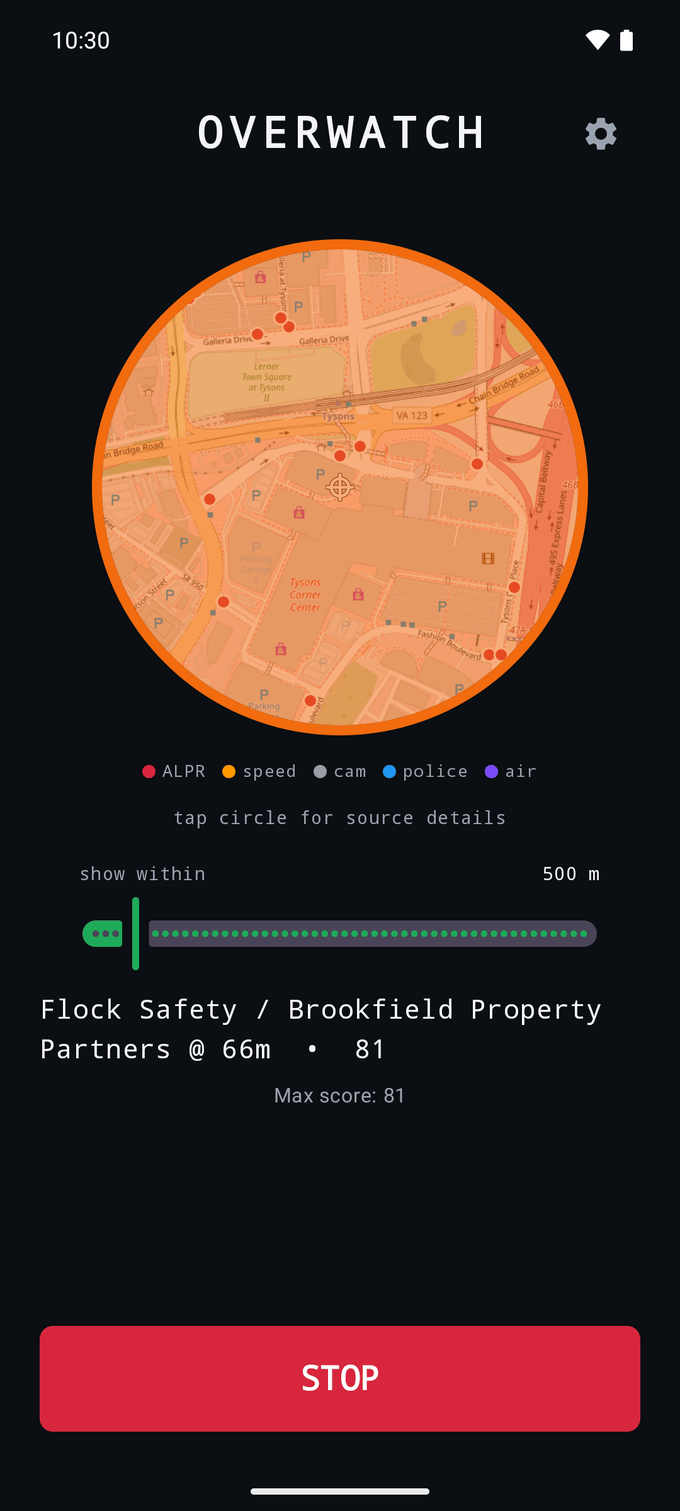
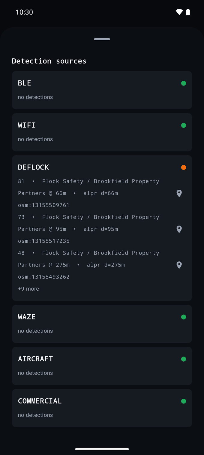
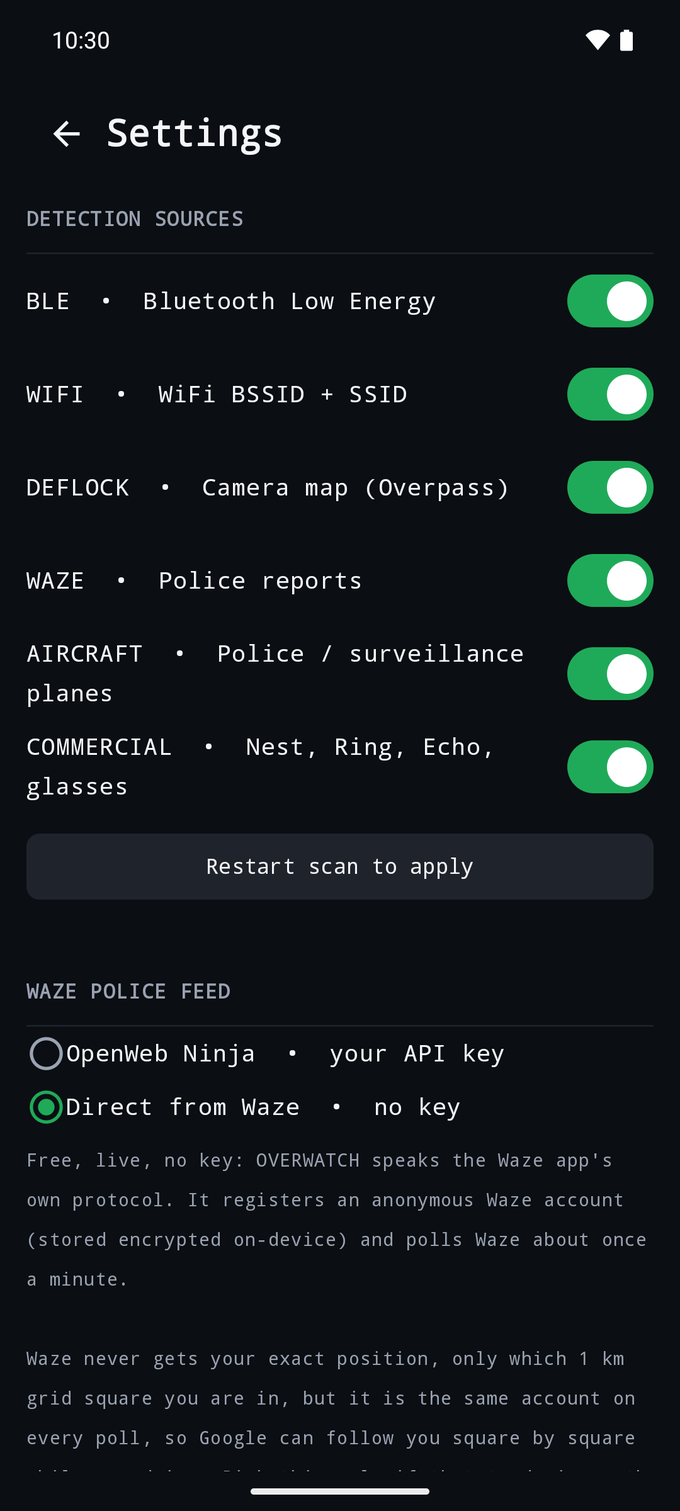
Live threat-map circle · source drill-down · settings — taken on v0.5.20 on an Android 16 emulator, so they don't show v0.6.0's Hacker and Tracker rows and toggles.
What it detects
| Source | What it looks at | Where it comes from |
|---|---|---|
| BLE | Bluetooth-LE advertisements: Axon body cams by the AXJANUSBWCDEVICE tag they broadcast (from public field captures; works on a randomised address), Axon's Bluetooth SIG IDs with their serials, its two MAC blocks and Utility's BodyWorn remotes; Raven service UUIDs; the Penguin battery pack's maker id 0x09C8 (XUNTONG) and "TN" serial; Flock name patterns anchored to the forms real devices use; 37 IEEE-verified surveillance-vendor blocks (Flock Safety's own b4:1e:52, ShotSpotter, WatchGuard, Digital Ally, Utility, Kustom Signals radar, Motorola Solutions, ELSAG, Genetec, Verkada, Avigilon Alta, Axis body cams, FLIR, Hanwha and more; 28- and 36-bit blocks included) with vendor-named labels. The radio-module makers' prefixes seen on Flock hardware count only alongside another signal. |
Local radio scan (BLE callback API), legacy and, where the phone supports it, extended / long-range advertising. Iterates every manufacturer-specific data entry. Screen off: Android suspends unfiltered scans, so the scanner switches to a filtered scan (Axon's tag, 0xFE6B and 0x034D, drone Remote ID, XUNTONG, Raven, then the COMMERCIAL UUIDs and company ids — 16 filters at most); OUI-prefix and name matching resume when the screen is on — see SOURCES.md §5.1. Police-exclusive vendors score ORANGE on sight, same rationale as Axon. |
| WiFi | Flock's hotspot SSID, Flock- plus the BSSID's last six hex digits (all 803 in flock-you's WiGLE data; the old four-hex pattern matched none), Flock's "Flock Camera" hotspot and other Flock tokens; the same 37 vendor blocks and Axon's; the radio-module prefixes seen on Flock hardware (flock-you's list, less Samsung's and Espressif's) as supporting evidence only. Flock turned its hotspot off around December 2025, so this mostly finds older cameras. |
WifiManager.getScanResults() polled every 35 s (just under the Android 9+ 4-scans/2-min throttle) |
| DEFLOCK | Mapped ALPRs, speed cameras and other surveillance cameras within 1.2 km, each scored on its own curve by how close it actually is | POST to Overpass API (overpass.deflock.org → fallback overpass-api.de) for every man_made=surveillance node plus highway=speed_camera, in a box ±0.05° around the centre of your 0.05° grid cell (never around your position), so Overpass learns only which ~5.5 km cell you are in; cached per cell for the current scan only, and deleted when scanning stops. Fetches the next cell as soon as your 1.2 km circle would reach past the loaded box, so every position is checked against a box that covers it (below about 64° latitude), and retries a failed fetch after 60 s. Treats {"remark": "...timed out..."} 200-responses as failure so timeouts don't poison the cache. |
| WAZE | User-reported POLICE alerts still active in the feed within 2 km, up to ~45 min old, scored by distance and age |
Two selectable backends. OpenWeb Ninja (default): api.openwebninja.com/waze/alerts-and-jams called with your own API key (X-API-Key, entered in Settings, stored encrypted on-device), polled every ~4 min with alert_types=POLICE&max_jams=0 (~1.5 KB/poll). Metered, lags live Waze by ~20 min, and Waze never sees you — the request is made by OpenWeb Ninja's servers, which are told the centre of your 1 km grid square, under your key. Direct (opt-in, off by default): speaks the Waze app's own protocol over an anonymous account OVERWATCH registers, polled every 60 s. Free, keyless and live, but it reports which 1 km grid square you are in to a Google service on every poll. Waze never gets the exact fix. Both re-filter to POLICE client-side so an upstream change can't let other types through. Alerts carry crowd-trust signals that nudge the score up. |
| AIRCRAFT | Police / surveillance aircraft overhead — identified from a bundled registry of 1,971 law-enforcement airframes, all but 36 of them American, plus loiter detection for unlisted ones — and drones, by their FAA Remote ID broadcast: the serial names the maker and often the model (BRINC, Skydio X10 / R10, DJI dock drones score highest), and the drone's own position puts it on the map | Aircraft: opendata.adsb.fi → fallback api.adsb.lol, polled every 60 s and told the centre of your 1 km grid square, not your position. No API key. Community ADS-B networks are used specifically because the commercial trackers filter law-enforcement flights at government request. Matched on the ICAO 24-bit address; scored by ground distance, altitude and orbit behaviour. Drones: heard directly over Bluetooth (service data 0xFFFA) and Wi-Fi beacons (vendor element FA:0B:BC, Android 11+); nothing is sent. |
| COMMERCIAL | Nearby consumer smart-home / voice gear (Nest, Ring, Blink, Echo, Sonos, hidden cams) and camera-bearing smart glasses (Meta Ray-Ban / Oakley — by their own service UUID 0xFD5F — Snap Spectacles, Vuzix, and HeyCyan-SDK frames such as the Nilox Smart AI Glasses) as a secondary situational signal |
Rides the BLE + WiFi scans — OUI / device-name / service-UUID / SSID matches plus Bluetooth SIG company IDs from MicTargets. Score-capped at ORANGE so a cluster of doorbells (or a passing pair of Ray-Bans) never reads as ALPR-grade certainty. |
| HACKER | Gear that transmits at radios: Flipper Zero (its own Bluetooth service, 0x3080–0x3083, and its remote / BadUSB mode), nyanBOX, Bluetooth pop-up spam floods (fake AirPods / Apple TV / Fast Pair / Samsung / Windows prompts) and the iOS crash advert, Wi-Fi beacon spam, the default hotspots of the WiFi Pineapple, ESP deauther, Bruce, GhostESP, O.MG and other tools, rogue-AP frameworks' default BSSIDs, ESP32 Marauder's fake "Flock" network, and AxonCadabra's spoofed Axon trigger. Optional card-skimmer check (HC-05-type modules). |
Rides the BLE + WiFi scans; identifiers come from each tool's own source. The skimmer check is a Bluetooth Classic discovery every 3 minutes, off by default (Settings → Look for card skimmers) because a module that answers gets a name request. Capped at ORANGE. |
| TRACKER | AirTags, Find My accessories, Google Find Hub tags, Samsung SmartTags, Chipolo and DULT tags that say they are away from their owner; Tile and Pebblebee tags, which never say, once they have stayed near you 10 minutes | Rides the BLE scan, following AirGuard's rules (seemoo-lab) and the IETF DULT draft. A tag beside its owner's phone never counts. Capped at ORANGE. |
Citizen was removed (v0.5.8). Citizen ended the police-dispatch data partnership behind its public feed in June 2026. It first degraded to silent empty stubs, and as of 2026-09-16
citizen.com/api/incident/trendingreturns HTTP 410 Gone —{"error":"This endpoint has been removed."}, which is upstream formally tombstoning it.data.sp0n.io(the host the current web app uses) answers 200 with a zero-byte body even with no query params. Structured incident data is now Citizen's paid Enterprise API only, which needs a business use-case application — not something this app can ship. The source and all its code were therefore deleted rather than left as a permanently-failing row. Police presence is still covered by Waze (denser for roadway stops anyway) and DeFlock.
Waze: pick a backend (v0.5.15+). The public
live-map/api/georssendpoint every scraper used is dead: it sits behind Google's edge, which returns HTTP 403 to automated clients regardless of IP, headers, TLS fingerprint, or headless-vs-headful browser — Waze's own page requests included. That is why v0.1.5 removed the original integration. OVERWATCH now offers two ways in, and the choice is a genuine trade rather than one being better. OpenWeb Ninja (the default) reads a hosted Waze feed with a key you supply yourself; it costs a few dollars a month and lags ~20 min, and the request comes from their servers, so Waze learns nothing about you — OpenWeb Ninja itself learns your 1 km grid square every 4 minutes, under your key. Direct speaks the Waze app's own protocol — free, keyless, live — but OVERWATCH then holds an anonymous Waze account and tells Waze which 1 km grid square you are in on every poll. That is never the exact fix, but one account reporting squares is still a coarse track a Google service can follow. It is off unless you turn it on. See Waze setup. Nothing is baked into the APK either way. The Waze for Cities partner feed was ruled out — it excludes POLICE and is agency-only.
Full reference: SOURCES.md documents every endpoint, every BLE/WiFi identifier, the scoring tables, and the sources that were tried and rejected (and why).
Every observation is scored 0–100 by ConfidenceEngine. The on-screen tier is
the maximum live score across all sources:
GREEN      < 40    nothing credible
YELLOW   40 – 69   single weak indicator
ORANGE   70 – 84   high confidence
RED        85 +    certain
DeFlock and Waze are scored on a sliding scale, not a flat value. Both carry real coordinates, so the score is a continuous falloff over the actual distance — drive toward a camera and the number climbs, drive past and it drops. The anchors are absolute metres and deliberately independent of the detection-radius setting: a camera 200 m away is equally close whether the slider reads 300 m or 5 km, so moving a setting must never move the threat level. A Waze report additionally decays by up to 12 points across its 45-min freshness window, because police move and a surveyed camera does not.
| Distance | DeFlock ALPR | Waze police (fresh) |
|---|---|---|
| 0 m | 95 RED | 80 ORANGE |
| 50 m | 85 RED | 75 ORANGE |
| 100 m | 72 ORANGE | 70 ORANGE |
| 200 m | 55 YELLOW | 63 YELLOW |
| 350 m | 42 YELLOW | 53 YELLOW |
| 500 m | 35 GREEN | 48 YELLOW |
| 1000 m | 26 GREEN | 35 GREEN |
| 3000 m | 18 GREEN | 23 GREEN |
Each curve crosses below the YELLOW line (40) at roughly the distance the thing stops being able to act on you. A Flock camera reads plates at ~30–50 m, so it is RED on top of it, ORANGE at 100 m, and GREEN by 500 m — still drawn on the map, just not an alarm. Waze keeps a wider band on purpose: a police car covers 700 m in under a minute; a bollarded camera never moves.
Scoring is fully decoupled from the range control. The scanners evaluate everything inside their own fixed radii (DeFlock 1200 m, Waze 2000 m, aircraft 15 km, or 8 km for an unlisted plane) and the tier is computed from that, so the slider cannot move it in either direction. It took two passes to get right: calibrating the curves stopped widening the range from dragging in distant noise, but narrowing it could still hide a genuine alert — a police report 312 m away scoring 52 vanished, and the circle went green, simply because the view was set to 300 m. Anything at YELLOW or above is now shown regardless of range. Measured: a camera 285 m away scoring 48 holds the tier at YELLOW from a 200 m view range all the way to 4900 m, and standing 29 m from one still reads 89 RED.
The user-facing circle uses the full 4-tier mapping, and its tier is the single
highest score among live detections. Sources are not combined: a BLE OUI hit and
a DeFlock map match in the same area read the same tier as the stronger of the
two alone. Several methods matching the same Bluetooth or Wi-Fi device do earn a
bonus, within that one observation. When idle,
the circle shows muted gray with IDLE text so it's distinguishable at a
glance from "scanning, all clear."
While scanning, the circle becomes a live OpenStreetMap centered on you, wrapped in a threat-color ring (the current tier at a glance) and marked with a ⌖ crosshair for your position. Map geodata is color-coded by source — Flock / DeFlock ALPR red, speed cameras amber, other cameras gray, Waze police blue, aircraft and drones violet — so each dot is self-explanatory. The same map renders in a smaller floating overlay bubble (Settings → Display over other apps) so it works over other apps.
How alerts work
- In-app: the threat circle shows a live map with a threat-color ring and source-color dots while scanning, with a legend beneath it — ALPR red, speed camera amber, generic camera gray, Waze police blue, aircraft and drones violet, and a ⌖ crosshair for your own position; tap it to open the bottom-sheet drill-down with per-source rows. DeFlock, Waze and aircraft rows carry coordinates and a tap-to-open Maps icon.
- Foreground notification: rebuilt on every threat-tier change. Title
becomes
OVERWATCH • RED(or whatever tier); text shows the top detection's score + label. It sits on a low-importance channel, so it updates silently and never pops up as a heads-up: the vibration is the alert. - Vibration: on upward tier transitions only. Short pulse for YELLOW, double for ORANGE, escalating triple for RED. Toggle in Settings → Alerts.
- Per-source health: when a scanner can't reach its data source, its row in
the drill-down says why in orange (e.g.
Overpass unreachable: HTTP 504), so a silent empty result and a real failure look different.
Architecture
ui/MainScreen.kt                   map circle + threat ring + START/STOP + drill-down sheet
ui/OverlayBubble.kt                floating "chat-bubble" version of the map circle
ui/MarkerIcons.kt                  map marker drawables — source dots + ⌖ user crosshair
ui/SettingsScreen.kt               source toggles, Waze backend + key/account, privacy, alerts, overlay, theme
ui/theme/Theme.kt                  Material 3 dark/light + threat colors
service/DetectionService.kt        foreground service — owns scanners, notification, vibration
service/OverlayManager.kt          WindowManager host for the floating overlay bubble
scan/BleScanner.kt                 BLE callback scanner (also HACKER, TRACKER and drone Remote ID)
scan/WifiScanner.kt                WifiManager poller + SCAN_RESULTS receiver (beacon spam, Wi-Fi Remote ID)
scan/ClassicScanner.kt             opt-in Bluetooth Classic discovery for card skimmers
scan/DeflockClient.kt              Overpass POST (deflock.org → overpass-api.de) + per-scan cell cache
scan/DeflockScanner.kt             location-driven proximity check + failure backoff
scan/WazeSource.kt                 the two-backend interface (alert + result types)
scan/WazeClient.kt                 backend 1 — GET api.openwebninja.com (user's own key)
scan/AircraftClient.kt             GET adsb.fi → adsb.lol (no key), live ADS-B contacts
scan/AircraftScanner.kt            60 s poller, registry match + loiter/orbit detection
data/targets/LeAircraft.kt         bundled ICAO-hex table of law-enforcement aircraft
scan/WazeScanner.kt                polls whichever backend is selected, client-side POLICE filter
scan/wazert/WazeRtClient.kt        backend 2 — Waze's own app protocol, anonymous account
scan/wazert/WazeRtFetcher.java     session + account + rate limits for backend 2
scan/wazert/*.java, proto/         vendored protocol layer + waze.proto (MIT, see credits)
fusion/ConfidenceEngine.kt         scoring (BLE / WiFi / DeFlock / Waze / aircraft / drones / Commercial / Hacker / Tracker)
fusion/RssiTracker.kt              rise-peak-fall stationary-signal detector
fusion/BleSpamDetector.kt          Bluetooth pop-up spam: fixed templates, floods, one transmitter cycling devices
fusion/DroneTracker.kt             joins one drone's Remote ID messages across adverts
fusion/TrackerDwell.kt             how long each tracker has stayed in range
fusion/DetectionStore.kt           in-memory dedup, 5-min retention, max-tier flow
fusion/SourceHealth.kt             per-source OK/FAILED registry for the drill-down
fusion/ThreatLevel.kt              4-tier enum + DetectionSource enum
data/location/LocationProvider.kt  FusedLocationProviderClient wrapper
data/location/PositionCloak.java   the 1 km grid square that is all ADS-B, OpenWeb Ninja and Waze learn of you
data/cache/LocationTraces.kt       deletes the camera cache (and, if asked, map tiles) at stop and start
data/settings/Settings.kt          SharedPreferences-backed StateFlow settings
data/settings/SecureStore.kt       Keystore AES/GCM store for the Waze key + anonymous account
data/targets/                      BleOuis, WifiOuis, VendorOuis, RavenUuids, Patterns, Manufacturers, MicTargets,
                                   AxonSignatures, HackerTargets, EspressifOuis, TrackerTargets, RemoteId
No detection-history database: detections live in memory and clear on stop, by design. Three things on the phone could show roughly where the app has been used, and all three are handled:
- Camera cache.
cache/deflock/keeps one Overpass response per ~5.5 km area scanned, so driving back through an area doesn't re-query it. It is deleted every time scanning stops, and again when scanning next starts in case the app was killed mid-scan. - Map tiles. The map keeps the OpenStreetMap tiles it showed, because OpenStreetMap's tile policy asks apps to cache them. Settings → Privacy → Delete map tiles when scanning stops deletes them on the same schedule.
- System log. The app writes no coordinates, cell names, request URLs or account details to Android's log. v0.5.17 and earlier logged the exact position on every camera-map fetch. v0.5.18 still quoted a malformed server reply whole, with the positions of the cameras, aircraft or police in it, and the direct Waze backend logged its account name; since v0.5.19 those lines carry the error's class only. One gap is outside the app's own code: the map library (osmdroid) logs a tile's number when that tile fails to download.
The service uses START_NOT_STICKY — system kill doesn't auto-restart into a
stuck state.
Waze setup (choosing a backend)
The Waze source reads user-reported POLICE alerts. There are two ways to get
them and they trade off against each other, so OVERWATCH ships both and lets you
pick under gear icon → Waze police feed.
| OpenWeb Ninja (default) | Direct from Waze (opt-in) | |
|---|---|---|
| Cost | ~7.5¢ per hour of scanning, your own key | free |
| Freshness | lags live Waze ~20 min | live |
| Poll | every ~4 min | every 60 s |
| What Waze learns about you | nothing — OpenWeb Ninja's servers make the request | an anonymous account and your 1 km grid square, every poll |
| What the feed's provider learns | OpenWeb Ninja: your 1 km grid square every 4 min, tied to your key | (Waze is the provider; see above) |
| Setup | sign up, paste a key | none |
Backend 1 — OpenWeb Ninja (default)
Each install uses its owner's own key; no shared credential ships in the APK and nobody has to be handed someone else's.
- Sign up at openwebninja.com.
- Subscribe to the Waze / Real-Time Traffic API (the
waze/alerts-and-jamsendpoint). - Copy your API key — it looks like
ak_…. - In OVERWATCH: gear icon → Waze police feed → OpenWeb Ninja → paste the key
→ Save. The status line flips to
API key set.
The key is stored encrypted on-device (Android Keystore AES/GCM, see
data/settings/SecureStore.kt) and is sent only to api.openwebninja.com as
an X-API-Key header. Clearing the field removes it and the source goes
dormant again.
What it learns. Each poll asks for alerts in a box around the centre of the 1 km grid square you are in, never around your position, so OpenWeb Ninja learns that square every 4 minutes, tied to your key. Waze itself never sees the request.
What it costs. Pay-as-you-go is roughly $0.005/request (OpenWeb Ninja's
pricing as of October 2026). OVERWATCH polls
about every 4 minutes while scanning, so ≈15 requests per hour of scanning,
which comes to about 7.5¢ an hour; an hour a day is about $2.25 a month.
The free tier's 100
requests/month is enough to confirm it works, not to run it continuously. The
app requests alert_types=POLICE&max_jams=0 so each poll is ~1.5 KB instead of
~18 KB, which matters on cellular but doesn't change the per-request price.
Watch your usage on the OpenWeb Ninja dashboard and set a spend cap there —
the app has no way to enforce one.
If a key is wrong or its quota is exhausted, the drill-down says so explicitly
(Invalid or missing API key (HTTP 401) / Rate limit or quota exceeded (HTTP 429)) rather than failing silently.
Backend 2 — direct from Waze (opt-in, off by default)
This speaks the protocol the Waze app itself speaks, so there is no key, no bill and no lag. Select it and it works; the first poll registers an anonymous Waze account (Waze mints the username and password) and stores it encrypted on-device, then reuses it.
Read this before turning it on. OVERWATCH becomes a Waze client. It holds a Waze account and, about once a minute while scanning, tells Waze which 1 km grid square you are in. Waze never gets your exact position: every message that carries a location is built from the centre of that square, and parking on a square's edge won't make it flicker between two squares (which would itself pinpoint you). But the account is the same on every poll, so a Google service can follow a drive square by square. The whole point of this app is knowing who is watching you, so it would be dishonest to bury that. If the trade isn't worth it to you, stay on OpenWeb Ninja, which tells Waze nothing (OpenWeb Ninja itself gets your square every 4 minutes, under your key).
v0.5.15 overstated this. Its Settings screen said the position was "blurred by up to 500 m". Only the register and login messages were. Every query carried the exact GPS fix, several times a minute. v0.5.16 changed the code to send only the grid square, and changed the wording to say exactly that. The wire-level evidence is in SOURCES.md §2.2b.
Practical notes:
- gear icon → Waze police feed → Direct from Waze, then Start (or Restart scan to apply if a scan is running). Nothing else to configure.
- Waze caps how many anonymous accounts a device may register per day, so the account is persisted and reused. Forget wipes it; the next poll mints a new one, a running scan's included, and that counts against the cap. (Before v0.5.19 a running scan kept using the forgotten account until you stopped it.)
- A rejected account (they get purged upstream) backs off 30 s → 10 min rather than spinning a re-register loop.
- A brand-new account's first request often draws a transient
504 Retryfrom Waze. That is normal and absorbed with a retry — it costs a couple of seconds on first run, not a failed poll. - Data use is ~200 KB on the first poll of a session and ~8 KB per poll after, because the session is kept alive. Polling slower here would use more data, since a re-login re-sends the whole viewport.
Build & install
Tested on Android 16 (API 36) with a punch-hole cutout as well as Android 14.
Requires:
- JDK 17+ (built and verified on 17; Gradle 9.x runs on 17 or 21)
- Android Studio with SDK Platform 37 + Build-Tools 36.x + Platform-Tools
Toolchain as of v0.5.16: AGP 9.4.1 / Gradle 9.8.1 / Kotlin 2.4.21, compileSdk
37. targetSdk stays at 35 deliberately — API 36+ tightens foreground-service
behavior, and screen-off scanning is the core feature, so the runtime opt-in is
kept separate from the compile-time bump. Note AGP 9 folds in Kotlin support, so
there is no longer a standalone kotlin.android plugin in the build file. Since
v0.5.15 the build also applies com.google.protobuf 0.10.0 (the first release
compatible with AGP 9) and generates the Waze RT message classes from
app/src/main/proto/waze.proto, so a clean build downloads a protoc binary.
# 1) Copy the example local.properties and point sdk.dir at your install
cp local.properties.example local.properties
# edit local.properties → sdk.dir=/Users/<you>/Library/Android/sdk
# (Waze needs no build config — paste your OpenWeb Ninja API key into Settings in-app)

# 2) Make sure JAVA_HOME is a JDK 17 or 21
export JAVA_HOME=/path/to/jdk-17

# 3) Build & install on a connected device with USB debugging
./gradlew :app:installDebug
Or download the latest debug-signed APK from Releases.
Releases are cut by CI: pushing a v* tag runs .github/workflows/release.yml,
which builds :app:assembleDebug and attaches the APK to a GitHub Release. No
build-time secrets — the app ships with no key or token. A fixed debug.keystore
is committed (a debug key is non-secret; password is the well-known android) so
every build — CI or local — signs identically and updates install in place
without an uninstall.
Permissions
| Permission | Why |
|---|---|
BLUETOOTH_SCAN, BLUETOOTH_CONNECT (API 31+) |
BLE scanning; CONNECT is needed only to read advertised device names — the app never connects |
BLUETOOTH, BLUETOOTH_ADMIN (≤ API 30) |
BLE scanning, and the opt-in skimmer check's Classic discovery, legacy |
ACCESS_FINE_LOCATION, ACCESS_COARSE_LOCATION |
Required for BLE pre-S, WiFi pre-T, and the distances DeFlock, Waze and aircraft are scored by |
NEARBY_WIFI_DEVICES (API 33+) |
WiFi scan results without using location |
ACCESS_WIFI_STATE, CHANGE_WIFI_STATE |
Trigger and read scan results |
INTERNET, ACCESS_NETWORK_STATE |
DeFlock Overpass, the Waze feed (OpenWeb Ninja or Waze direct), ADS-B aircraft feeds, OpenStreetMap map tiles |
FOREGROUND_SERVICE, FOREGROUND_SERVICE_CONNECTED_DEVICE, FOREGROUND_SERVICE_LOCATION |
Keep scanning with the screen off (note: a foreground service does not exempt BLE from the unfiltered-scan screen-off rule — see SOURCES.md §5.1) |
POST_NOTIFICATIONS (API 33+) |
Foreground-service notification |
VIBRATE |
Haptic alert on threat-tier escalation |
SYSTEM_ALERT_WINDOW |
Optional floating threat-circle overlay (special-access; granted via system settings) |
Requested at runtime when you press START for the first time. If you permanently deny a required permission ("don't ask again"), an Open app settings button appears under START (and START itself opens the same page) so you can grant it manually.
Settings
Tap the gear icon in the top-right.
- Detection sources: toggle BLE / WiFi / DeFlock / Waze / Aircraft (planes and drones) /
Commercial / Hacker / Tracker independently, plus Look for card skimmers under Hacker
(off by default). Changes take effect on the next Start (Commercial, Hacker, Tracker and
drones apply right away). While
scanning, a Restart scan to apply button appears that does
stop()+start()in one tap; it applies the Waze backend choice too. (v0.5.18's restart kept the backend the scan had started with.) - Range (
show within) lives on the main screen, under the map — it's the one control you reach for while moving. 100 m – 5000 m, default 500 m, committing on release rather than per-pixel so the map isn't re-zoomed on every frame of a drag. It is a view control, not a sensitivity control: it sets what the circle draws and what the drill-down lists, and nothing else. The scanners evaluate at their own fixed radii regardless of it, so moving it in either direction cannot change the threat tier — and anything at YELLOW or above is shown whatever the range says, because a view setting that could hide a live alert would be a trap. - Waze police feed: choose a backend — see Waze setup. OpenWeb Ninja (default) needs your own API key, stored encrypted on-device (Android Keystore) and never baked into the APK; empty key = Waze source off. Direct from Waze needs no key but registers an anonymous Waze account and reports your 1 km grid square each poll (never the exact fix), so it is off until you pick it; Forget wipes the stored account, and a running scan switches to a new one at its next poll.
- Privacy: says what the online sources learn (your 1 km grid square; the camera map, its ~5.5 km cell) and that a row's map pin opens Google Maps. The camera cache is always deleted when scanning stops. Delete map tiles when scanning stops (default off) does the same for the map's OpenStreetMap tiles, which are otherwise kept because OpenStreetMap asks apps to cache them.
- Alerts:
- Vibrate on threat escalation (default on)
- Display over other apps: floating threat-circle overlay (needs the special-access permission; the app bounces you to the system page to grant it).
- Appearance: System / Dark / Light (default Dark)
Reference repos studied while building
These live under REFERENCES/ (gitignored):
- AxonCadabra — BLE scanner skeleton (scan side only; advertise/fuzz code excluded)
- flock-detection — confidence-scoring algorithm (highest reusability), RSSI rise-peak-fall, OUIs + UUIDs + patterns
- flock-you — its 31-prefix Flock WiFi list (promiscuous-mode tricks not portable to Android)
- deflock + deflock-app — Overpass query format + proximity-alert pattern (the Flutter app uses Overpass directly, not the CDN tiles, which the OVERWATCH client mirrors)
- wazepolice — original live-map/api/georss recipe; that endpoint now 403s at Google's edge, so OVERWATCH reads either OpenWeb Ninja's hosted feed or Waze's own app protocol instead
- Studied for v0.6.0, identifiers only (none of their code is in OVERWATCH): all-cameras-are-beacons (Apache-2.0; Axon field captures), nite-oui-collection (MIT; BodyWorn), flock-you's WiGLE datasets (MIT), OpenDroneID receiver-android and opendroneid-core-c (Apache-2.0; Remote ID), AirGuard (Apache-2.0; trackers), flipperzero-firmware, Momentum, Wall of Flippers (MIT), nyanBOX (MIT), ESP32 Marauder (MIT), AppleJuice, ESP32-Sour-Apple, esp8266_deauther (MIT) and other tools' sources for HACKER, and SquachWatch-CYD (GPL-3.0) for comparison. Every MAC block and Bluetooth number was checked against the IEEE and Bluetooth SIG registries; drone serial prefixes against the FAA's public Remote ID declarations. Per-identifier sources are in SOURCES.md §3.
- Nearby Glasses by Yves Jeanrenaud (AGPL-3.0) — the curated smart-glasses identifier set behind the GLASSES family in the COMMERCIAL source: the Bluetooth SIG company ids for Meta / Luxottica / Snap, the HeyCyan-SDK primary service UUID that identifies the Nilox Smart AI Glasses, and the
rayban/heycyanname tokens. OVERWATCH uses the project's published identifiers (facts about the radio protocol), not its code, and re-verified every company id against the SIG registry. One deliberate divergence: Nearby Glasses also matches0x05D6(Zhuhai Jieli); OVERWATCH does not, because that is the id of a Bluetooth chipset found in a huge share of cheap earbuds and speakers, and this app's COMMERCIAL source is tuned against false positives rather than for recall.
- highway-radar-sabre-plus (MIT) — the Waze RT protocol layer behind the direct Waze backend. Unlike every other reference here, this one is vendored, not just studied: the files in
app/src/main/java/org/soulstone/overwatch/scan/wazert/andapp/src/main/proto/waze.protoare that project's code under its MIT licence, unmodified apart from the package name, the removal of the report-submission path, an OkHttp-to-HttpURLConnectionrewrite of the HTTP client so OVERWATCH takes no extra dependency, and log lines that no longer print the account name or session id. The exception isWazeRtFetcher.java, OVERWATCH's own slimmed driver modelled on upstream's and carried under the same licence, whose text sits in that directory. The position cloak the backend applies is OVERWATCH's own (data/location/PositionCloak.java). OVERWATCH reads alerts and never reports.
Status
Phases 1–5 (skeleton, BLE, WiFi, DeFlock, polish) complete and field-tested. Current release v0.6.0. Notable changes:
- v0.1.2 — Android 14+ foreground service type fix; NaN-coordinate filter on map data.
- v0.1.3 — DeFlock CDN replaced by direct Overpass calls (Cloudflare-blocked).
- v0.1.4 — Citizen.com added as 5th source, per-source health registry. (source removed in v0.5.8 — feed retired upstream)
- v0.1.5 — Waze removed (the
live-mapendpoint started 403ing; no clean mobile workaround at the time). - v0.1.6 — Dynamic notification with tier + label, haptic alerts, Open-in-Maps for geo events.
- v0.1.7 — System back from Settings returns to MAIN instead of exiting.
- v0.2.0 — Live map circle + COMMERCIAL source (Nest / Ring / Echo / hidden cams).
- v0.2.1–v0.2.2 — Live proximity refresh, map dot markers, map + Settings UI polish.
- v0.3.0–v0.3.2 — Floating threat-circle overlay (chat-bubble style) + drag/crash fixes.
- v0.5.0 — Waze re-added via a key-protected Caddy proxy (
api.blackflagintel.com): the OpenWeb Ninja key stays server-side, the app uses an encrypted per-device token. GitHub Actions release pipeline added. - v0.5.1 — UI: larger map circle with a threat-color ring, ⌖ user crosshair, source-color dots (Flock red / Waze blue), START moved to the bottom.
- v0.5.2 — Committed a fixed debug keystore so CI + local builds sign identically; updates now install in place (no functional changes).
- v0.5.3 — Detect Meta / Snap / Vuzix smart glasses in the COMMERCIAL source (BLE company-id + name vectors); new radar app icon (launcher, themed, and notification).
- v0.5.4 — 18 IEEE-verified surveillance-vendor OUIs across BLE + WiFi (ShotSpotter, WatchGuard/Motorola, Verkada, Avigilon Alta, Axis, FLIR, Hanwha, March Networks, GeoVision, Mobotix, Sunell); police-exclusive vendors (WatchGuard, ShotSpotter) score ORANGE on sight; vendor-named drill-down labels.
- v0.5.5 — Citizen feed confirmed retired upstream; the source now reports the shutdown instead of leaking a JSON parse error, and backs off to a 30-min heartbeat. Toolchain modernized: AGP 9.3.2, Gradle 9.7.1, Kotlin 2.4.10, Compose BOM 2026.08.00,
compileSdk37 (targetSdkheld at 35); CI actions bumped off deprecated Node-20 versions. - v0.5.6 — Waze now calls OpenWeb Ninja directly with your own API key instead of a shared proxy token; the
api.blackflagintel.comproxy is no longer used and the stale token is purged from the secret store on upgrade. Requests addalert_types=POLICE&max_jams=0(~18 KB → ~1.5 KB per poll). See Waze setup. - v0.5.7 — (Never released: these changes shipped in v0.5.8.) Citizen source removed entirely (client, scanner, scoring, settings, map dots and the drill-down row). Its endpoint now returns HTTP 410 Gone, so there was nothing left to degrade gracefully into. OVERWATCH is now a five-source app: BLE, WiFi, DeFlock, Waze, Commercial.
- v0.5.8 — AIRCRAFT source: police / surveillance aircraft overhead via free community ADS-B feeds, matched against a bundled 1,971-entry registry of law-enforcement airframes, nearly all American (regenerate with
scripts/gen-le-aircraft.py), plus loiter/orbit detection so unlisted aircraft circling overhead still register. Overpass query widened to speed cameras and generic surveillance nodes, each scored on its own curve. DeFlock/Waze/aircraft all scored by continuous distance falloff. New SOURCES.md reference. - v0.5.9 — Detection-radius slider moved onto the main screen (under the map, where you reach for it while moving) and a source-color legend added beneath the circle: ALPR red, speed camera amber, other cameras gray, Waze police blue, aircraft violet.
- v0.5.10 — Recalibrated every distance curve so the range slider can no longer move the threat tier: each crosses below YELLOW at roughly the distance the thing stops being able to act on you (ALPR is RED on top of it, GREEN by 500 m). The main-screen slider is relabelled
show withinto say what it is — a view control, not a sensitivity control. - v0.5.11 — Android 15/16 and cutout-display compatibility. Opts into edge-to-edge explicitly and pads every screen with
WindowInsets.safeDrawing; reproduced on Android 16 with a punch-hole, where v0.5.10 drew its title inside the status bar and buried the gear icon under the wifi/battery icons. The overlay bubble now states its cutout mode so it can't park under a camera hole. BLE screen-off fix: Android suspends unfiltered scans when the screen turns off and a foreground service does not exempt it, so the scanner switches to a filtered scan (Raven UUIDs, XUNTONG, mic company ids, capped at 16) while the screen is off — see SOURCES.md §5. - v0.5.12 — The range slider can no longer change the threat tier in either direction. v0.5.10 stopped widening it from pulling in distant noise, but narrowing it still hid real alerts: a police report 312 m away scoring 52 disappeared and the circle went green because the view was set to 300 m. Scanners now evaluate at their own fixed radii (DeFlock 1200 m, Waze 2000 m) instead of the user's setting, events carry their distance, and anything at YELLOW or above is displayed regardless of range.
- v0.5.13 — Fixed the map coming back fully zoomed out (whole world) after the first stop/start. The camera-position guard added in v0.5.9 was remembered outside the branch that owns the
MapView, so a rebuilt map compared against the previous map's position, saw no change, and never zoomed in. Scoped it to the map's own lifetime. Reproduced deterministically from the second start onward and verified over five cycles. - v0.5.14 — Smart-glasses coverage extended from the Nearby Glasses identifier set (credit: Yves Jeanrenaud): the HeyCyan-SDK service UUID that identifies Nilox Smart AI Glasses and other HeyCyan frames, case-insensitive
rayban/ray-ban/heycyanname tokens, and service UUIDs are now also read from advertised service-data keys, where those glasses have been seen to carry them. The HeyCyan and Echo service UUIDs join the screen-off ScanFilter set, so glasses can be caught with the phone in a pocket. Also fixes a pre-existing mislabel found while re-verifying every company id against the Bluetooth SIG registry:0x05A7is Sonos, not a hidden-cam vendor — it now reads "Sonos speaker" instead of "Possible hidden mic / cam". - v0.5.15 — A second Waze backend: straight from Waze, no API key. The public
live-map/api/georssendpoint 403s automated clients at Google's edge, so until now the only way in was OpenWeb Ninja's metered feed. OVERWATCH can now instead speak the Waze app's own protocol over an anonymous account it registers itself: free, keyless, live, and polled every 60 s instead of every 4 min. It is off by default and opt-in, because it makes the app a Waze client — it holds a Waze account and sends a position to a Google service on every poll, and in a surveillance-detection app that has to be your call, not a default. (Correction: this entry originally said that position was blurred by up to 500 m. It wasn't — v0.5.15 sent the exact fix. See v0.5.16.) OpenWeb Ninja remains the default and is unchanged; pick either under gear → Waze police feed. See Waze setup and SOURCES.md §2.2. The protocol layer is vendored from highway-radar-sabre-plus (MIT, credited below), with the report-submission path removed — OVERWATCH reads alerts and never reports one. Also: radio rows in Settings are now tappable across their whole width instead of only on the 20 dp circle. - v0.5.16 — Privacy fix: the direct Waze backend no longer sends your exact position. v0.5.15's Settings screen said the position sent to Waze was blurred by up to 500 m. Only the register and login messages were. The handshake's
Locationline and the centre of every map query carried the exact GPS fix, several times a minute. Every message that carries a location is now built from the centre of the 1 km grid square you are in, with 150 m of hysteresis so parking on a square's edge can't make it flicker between squares and pinpoint you. Detection is unchanged: distances are still measured on the phone from the real fix, and the area Waze is asked about grows to cover the difference. Verified on the wire: two real positions 745 m apart in one square produce byte-identical requests (SOURCES.md §2.2b). Settings, this README, SOURCES.md and the website now say exactly that. Also: OVERWATCH is now BSD 3-Clause licensed — it had no license file, so it wasn't actually open source — and release builds pass lint again (androidx.fragment constrained to 1.9.1). Toolchain and libraries brought current: AGP 9.4.1, Gradle 9.8.1, Kotlin 2.4.21, Compose BOM 2026.09.00, core-ktx 1.19.1, protobuf 4.36.2. - v0.5.17 — No more location trail, fewer false Raven alarms, and claims that match the code. The camera cache recorded every ~5.5 km area you scanned and was never deleted; it is now deleted every time scanning stops, and again at the next start in case the app was killed mid-scan. Map tiles stay cached by default, as OpenStreetMap asks, and Settings → Privacy → Delete map tiles when scanning stops removes those too. Raven detection no longer fires on ordinary Bluetooth gear: three of its eight service UUIDs are standard ones a Bluetooth thermometer or GPS unit advertises, and any single one used to score ORANGE as a gunshot detector. They now count only as the full set of three that Raven's oldest firmware advertises, while Raven's own five UUIDs still count alone, so every documented Raven firmware scores as before. Docs, site and Settings now say what the app actually does: it never connects to, pairs with or jams what it detects, though its scans do transmit; 36 of the 1,971 registry aircraft are foreign police; the tier is the single highest score, not a sum across sources; and the paid Waze feed costs about 7.5¢ per hour of scanning.
- v0.5.18 — No online source learns your exact position any more, and four bugs fixed. v0.5.16 stopped sending the exact fix to Waze, but the other online sources still had it: the ADS-B aircraft feeds got your position to about 11 m every minute, OpenWeb Ninja got a box centred exactly on you every 4 minutes, and Overpass got a box centred on you at each camera-map fetch. Now the aircraft feeds and OpenWeb Ninja are told only the centre of the 1 km grid square you are in (the same cloak, moved to
data/location/PositionCloak.java), and Overpass only its ~5.5 km cache cell. Detection is unchanged: distances are still measured on the phone from the real fix; OpenWeb Ninja's box grows by the up to 919 m the square's centre can be from you, and the aircraft query's 30 nm radius already covers it. Fixes: the camera-map fetch no longer writes your exact position to Android's system log; the aircraft source failed with HTTP 400 on phones set to a comma-decimal language (German, French, Spanish and many more), because it formatted coordinates in the phone's locale; Restart scan to apply could leave scanning stopped, because its STOP ended the service without regard to the START right behind it; and the camera map could miss cameras near the edge of its cached area, because the box was centred on whichever position first filled the cell. Also: COMMERCIAL now finds a matching Bluetooth company id even when a device advertises it second, a rejected direct-Waze account now backs off all the way to the documented 10 minutes, and Settings, this README, SOURCES.md and the site now say all of this, drop a promised heads-up notification the app never shows, and fix wrong score-table cells. (Correction: this entry originally said every query area grows to cover the difference, and that no log line carries a coordinate. Only OpenWeb Ninja's grows, and a malformed server reply was still logged whole, positions included. The release also had two gaps it didn't mention: for a while after you entered a new cell, the camera map still checked you against the old cell's box, and the Restart fix made Restart keep the Waze backend the scan had started with. All fixed in v0.5.19.) - v0.5.19 — Two Waze privacy fixes, a camera map that loads reliably, and no server replies in the log. Restart scan to apply now applies a Waze backend switch: v0.5.18's restart fix kept the running service, which had picked its backend when it was created, so switching from Direct to OpenWeb Ninja and restarting kept sending your grid square to Waze until a full Stop. The backend is now built at every Start. Forget now reaches a running scan: it wiped the stored account, but the scan carried on logging in as that account until Stop; now its next poll registers a new one (verified against v0.5.18's fetcher, which logged in again as the forgotten account). The camera map could stay empty: a location fix arriving during a fetch cancelled it and threw the reply away, which at Start, when the phone's cached position and its first live fix land within a second, could lose the first fetch; and a failed fetch was retried only after you had moved 1.5 km. In a test with the v0.5.18 scanner, a parked phone was still without cameras after 70 s either way. Now a fetch always finishes and a failure is retried after 60 s. The map also no longer checks you against the previous cell's box for a while after you cross into a new cell (0.64% of fixes at 38°N and 11.7% at 60°N had part of their 1.2 km circle outside it on simulated drives; now none below about 64°): it fetches the new cell as soon as your circle would reach past the loaded box. Logs: a malformed reply from Overpass, the aircraft feeds or OpenWeb Ninja was written to Android's log whole, with the positions of the cameras, aircraft or police around you in it, because Android's JSON parser quotes its entire input in a syntax error; the direct Waze backend logged its anonymous account name, and an unreadable stored account would have been logged with its password. Those lines now carry the error's class only. Detection: Flock Safety's own IEEE-registered MAC prefix,
b4:1e:52, which neither Flock list ever carried, is now matched over BLE and WiFi and labelled "Flock Safety device"; like the other vendor OUIs it scores 40, YELLOW. Docs: SOURCES.md now lists Google Maps as a destination, for when you tap a row's map pin; the "Flock" OUI lists are described as what they are, radio-module makers' prefixes seen on Flock hardware, none registered to Flock; the hidden-camera OUIs carry their real owners (three are Espressif), and the Amazon and Google sets are documented as holding six prefixes registered to other companies; the aircraft registry's agency counts add up every spelling (DHS 306, Arizona DPS 67); SOURCES.md states the score of 40 below which a radio hit is never shown, and the OpenWeb Ninja prices as of October 2026; and the screenshots are labelled as v0.5.5 or earlier. - v0.5.20 — Map detections follow you, and two dark-theme fixes. A mapped camera or a Waze police report now leaves the screen as soon as you are out of its range. Until now each stayed for up to 5 minutes after you left it, still showing the distance it had when last in range: after a jump in position (the phone's cached location from somewhere else at Start, a GPS glitch, the end of a tunnel) the screen kept reading "Flock Safety @ 66m" with an orange ring 12 km away. Cameras and reports don't move, so both sources now re-score everything at every fix; cameras left behind are dropped before the new area's map arrives, and after a failed Waze poll the last reports still stay for 5 minutes. BLE, WiFi, Commercial and aircraft detections keep their 5-minute memory, since the app can't re-measure those between sightings. The status-bar icons follow the app's theme, not the phone's: the app defaults to dark, so a phone in light mode drew dark icons on the dark background. The Settings back arrow shows in the dark theme; it had been black on near-black since v0.1.0. New screenshots here and on the site, from an Android 16 emulator parked at Tysons Galleria in Virginia, replacing ones from v0.5.5.
- v0.6.0 — Two new sources, police drones, Axon by its own broadcast, and Flock rules that match real Flock devices. HACKER flags gear that transmits at radios: a Flipper Zero by its own Bluetooth service (
0x3080–0x3083, and its remote/BadUSB mode), nyanBOX, Bluetooth pop-up spam floods and the iOS crash advert, Wi-Fi beacon spam, the default hotspots of the WiFi Pineapple, ESP deauther, Bruce, GhostESP, O.MG and others, rogue-AP frameworks' default BSSIDs, and AxonCadabra's fake Axon trigger. An optional card-skimmer check (Bluetooth Classic discovery for HC-05-type modules) is off by default because it pages the modules it finds. TRACKER flags AirTags, Find My and Find Hub tags, SmartTags, Chipolo and DULT tags that say they are away from their owner, and Tile or Pebblebee tags once they have stayed near you 10 minutes. Drones join AIRCRAFT through their FAA Remote ID broadcast, over Bluetooth (including long range, where the phone supports it) and Wi-Fi beacons; the serial names the maker and often the model, so a BRINC Responder, a Skydio X10 or a DJI dock drone scores higher than a hobby drone, and the drone's own position puts it on the map. Axon body cams are found by the tag they broadcast (AXJANUSBWCDEVICE, from all-cameras-are-beacons' field captures), even on a randomised address and with the screen off, along with Axon's Bluetooth IDs and serials, its second MAC block and Utility's BodyWorn remotes. Flock fixes: the hotspot rule expectedFlock-+ 4 hex and matched none of the 803 real ones in flock-you's WiGLE data, which areFlock-+ 6 hex ending in the BSSID;0x09C8is labelled as the Penguin battery pack it is, not Raven's maker;Pigvision, which no device was ever seen to use, is gone; Penguin,FS-and numeric names are anchored to the forms real devices use. The radio-module makers' prefixes seen on Flock hardware no longer alert on their own (they score 25, under the display floor), and Samsung's and Espressif's blocks are out of the list, so a Samsung TV or an ESP32 smart plug is no longer a "Flock" detection. More vendors: 18 more IEEE-verified blocks, among them Digital Ally, Utility, Kustom Signals and Stalker radar, Motorola Solutions, Federal Signal, Fusus, ELSAG, Neology and Genetec, with 28- and 36-bit blocks now matched; Ring's 13 and Blink's 6 blocks in COMMERCIAL; Ray-Ban Meta's own0xFD5F, while0x058E, which Quest headsets send, no longer reads as glasses. The source sheet scrolls, and a source whose network half fails (ADS-B) still lists what its radio half found. Also fixed: the Penguin "TN" serial check could read one byte past the end of a payload.
License
OVERWATCH is released under the BSD 3-Clause License.
Some files in this repository are third-party material under their own terms:
- Waze protocol layer.
app/src/main/proto/waze.protoand everything inapp/src/main/java/org/soulstone/overwatch/scan/wazert/derive from highway-radar-sabre-plus and stay under its MIT License, whose text is kept in that directory. (WazeRtFetcher.javathere was written for OVERWATCH on upstream's model and is carried under the same license.) - Aircraft registry.
app/src/main/res/raw/le_aircraft.csvis derived from ADSBexchange'sbasic-ac-db, which is built mostly from the public FAA aircraft registry (it also lists the foreign police aircraft included here). Regenerate it withscripts/gen-le-aircraft.py. - Web fonts. The fonts in
docs/fonts/are under the SIL Open Font License 1.1; seedocs/fonts/OFL.txt.
The reference repos informed algorithms and supplied published identifiers such as OUIs and service UUIDs. Apart from the vendored Waze protocol layer above, their code is not redistributed here.
Disclaimer
Tool for situational awareness about deployed surveillance infrastructure in public spaces. Local laws regarding electronic surveillance, RF monitoring, and police-tracking apps vary — your responsibility to know what's legal where you are.
Explore related projects
trimstray/the-book-of-secret-knowledge
A collection of inspiring lists, manuals, cheatsheets, blogs, hacks, one-liners, cli/web tools and more.
257,250 starsHack-with-Github/Awesome-Hacking
A collection of various awesome lists for hackers, pentesters and security researchers
125,103 starsswisskyrepo/PayloadsAllTheThings
A list of useful payloads and bypass for Web Application Security and Pentest/CTF
82,542 starscaddyserver/caddy
Fast and extensible multi-platform HTTP/1-2-3 web server with automatic HTTPS
78,935 stars